|
|
|
Geography of
Guangxi |
|
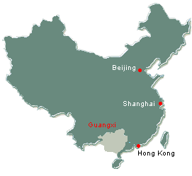
Guangxi, with full name Guangxi Zhuang Autonomous Region is situated in
China's southern frontier area, facing Beibuwan Gulf in the south (The
total length of the coast line is about 1,500 kilometres.) and bordering
Viet Nam on the southwest. During the Northern Song Dynasty (960
A.D-1127 A.D), this region was under the administration of Guangnanxi Lu
(lu, ancient name for province), which was later abbreviated as Guangxi
Lu, hence the name Guangxi. In the Qin Dunasty(221 B.C-207 B.C), the
region was under the administration of Guilin Jun and Xiang Jun (jun,
ancient name for prefecture), and became known as Gui subsequently.
The whole region
covers an area of over 236,700 square kilometres with a population of
49.25 million, comprising nationalities of
Zhuang,
Han,
Yao,
Miao,
Dong,
Mulan,
Maonan,
Hui,
Jing,
Yi,
Sui and
Gelao. Over
ninety percent of Zhuang population, which is the largest minority group
in China, live in Guangxi, Nanning is the capital of the region.
Guangxi is surrounded by a long and unbroken mountains, with the central
part of the Region constituting a land of gentle karsts hills and
plains, known as the Guangxi Basin", Mar'ershan, 2,142 metre above sea
level, is the peak of Yuechengling Mountain and the highest peak in
Guangxi as well. A natura; xone was set up in the Mao'ershan area.
The Huaping Natural Rwserve Zone is located on the densely wooded hill,
1,500 metre above sea level, the north-eastern and northern part of
Guangxi. With limestone covering half of the Region, Guangxi is one of
the areas in China with large well-developed karsts formations.
|
|
|
Guangxi Climate |
|
Located in a subtropical area and enjoying a humid and monsoon
climate, Guangxi has long and hot summer, and occasionally cold
winter, with distinctive dry and rainy seasons. The annual average
temperature is 17ºC-23ºC
(62.6 ºF and
73.4 ºF), with a
frost-free period exceeding 300 days. The annual rainfall averages
between 1,000mm to 2,800mm. |
|
|
Brief History of
Guangxi
|
The Region was called Baiyuedi in ancient times and various
administrations were set up in Guangxi in different dynasties: in the
Qin Dynasty (221 B.C-207 B.C), it was under the administration of
Guilin Prefecture and Nanhaixiang Prefecture; in the Tang Dynasty (618
A.D-907 A.D), it belonged to Lingnandao Prefecture; in the Song Dynasty
(960 A.D-1297A.D), it came under the jurisdiction of
Guangnanxi Lu, later known as Guangxi; in the Yuan Dynasty( 1271
A.D-1368 A.D), it became part of Hunan-Guangxi Province; in the Ming
Dynasty(1368 A.D-1644 A.D), it was under the administration of Guangxi
Department and become Guangxi Province in the Qing Dynasty (1644
A.D-1911A.D). In March 5,1958, Guangxi Zhuang Autonomous Region was
officially set up.
|
|
|
|
|
|
|
Places of Interests and Tourist Attractions of
Guangxi |
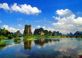
Lijiang River
A well-known part of the Guilin River, it flows from the
Piled Festoon Hill to "Bilian Peak" in Yangshou, covering a
distance of 83 kilometres. This green ribbon-like river runs
zigzag through a multitude of hills against a backdrop of
steep peaks, luxuriant flowers and green hills along the
shores are mirrored in the blue water, giving the visitor a
poetic inspiration. In drizzly days, the peaks embraced by
clouds and mists and river.
(Click for more about Li River.)
Lijiang (Li)
River
Elephant Trunk Hill
The hill is at the confluence of the Lijiang River and
Yangjiang River inside the city. This hill is so named
because it outlines a vivid image of an elephant sipping
water from the river with its trunk. Between the body and
the trunk there is a round-shaped space, known as "water
moon" arch, which is about 10 metres high and 20 metres
deep. The river flows through the arch resembling a
"bright-moon". Sailing through the arch, one feels like
being under a huge arch bridge.
Crescent Hill
Located to the east of Guilin, the hill gets its name from a
new-moon shaped opening of a cave in the western slope of
the hill. The hidden Dragon Cave at the food of the hill has
a stretch of water and a food path, Yihong Pavilion", "Xiaoguanghan
Temple" and other buildings are located half way up the
hill.
Fubo Hill
It is located to the east of the city with half of the hill
reaching into the Lijiang River. The hill stands in solitary
loftiness with a thrusting peak. It seems to restrain the
swelling water when the river is raising with violent
torrents and waves, hence the name Fudo (restraining waves).
On the hilltop there is a Fudo Temple and the Returning
Pearl Cave. At the foot of the hill, there are other scenic
spots.
Seven-Star-Rock Cave
Formerly known as "Qixia Cave" and "Bixu Rock", It is on the
Seven star-Rock hill to the east of Guilin. The cave
presents a twisted extension of more than one and a half
kilometres. This cave, the biggest and the most fascinating
cave of Guilin, includes "Liudongtian Cave" and Liangdongfu
Cave, offers numerous spectacular views and is big enough to
hold ten thousand visitors at a time; originally, the cave
was an underground channel and became a tourist attraction
as early as the Sui and Tang Dynasties (581 A.D.-907).
Inside the cave, well-developed stalactites and stalagmites
form numerous fantastic scenes such as `Monkey Picking
Peaches`, `Two Lion Fighting for a Ball`, or in the shapes
of fruits, forests and gigantic waterfall.
Reed-Flute Cave
The cave is at the Guangming Hill about six kilometres
northwest of Guilin. This huge cave, eroded out of karst
formation and with a maximum height of 18 metres and width
of 93 metres. This ancient scenic spot dates back to more
than 1,000 years ago, It has been widely claimed as Art
Galley of Nature" because of its dazzling beauty of strange
karts formation and marvellous scenery.
Weizhou Island
Weizhou Island, Beihai, Guangxi
|
|
|
Cities in Guangxi |
-
Nanning - The
Capital City of Guangxi
-
Guilin -
One of China's most
famous tourist city
- Yangshuo
- The town is situated on the west bank of the Lijiang River about
60 kilometres away from Guilin. With its limestone formations and
enchanting landscape, the town has enjoyed the fame of "having even
more beautiful scenery than "Guilin" since ancient time. Yangshou
won fame for its green hills, charming waters, peculiar peaks, and
exquisite caverns. "People live as if in paintings" is a vivid
description of the Yangshou landscape.
- Liuzhou -
One of the ancient cities in southern China, it has a history of
more than 2,000 years. "Peculiar peaks rise abruptly from the plain
as if on a painting scroll" is a vivid depiction of the marvellous
Liuzhou landscape and its exquisite karsts formation. Local scenic
spots are: Liu Huo Park, Dule Tourist Resort, Yufeng Peak and
others.
- Wuzhou -
It is an aged-old city. Towards the end of the Qin Dynasty, Cangwu
Jun was set up here. During the fourth year of the reign of Emperor
Wude, the Tang Dynasty (621 A.D), it was renamed Wuzhou. Known as
"the door of Guangxi", it is a hub of river navigation and transport
in the Region. It offers a beautiful natural landscape encircled by
green hills and chequered with strips of blue water. Major tourist
attractions are Sun Yatsen Park, Hebin(riverside) Park, Longzhou
Island and so on.
|
|
|
|
|
|
Useful Links
about Guangxi |
|
|
|
|
Related Report Links of Guangxi |
|
|
|
|
|
|
|
|
|
|
|
|